Fieldwork in the Atacama Desert, Chile

Thursday 13 December 2012

Cladocora caespitosa; from reefs to crystals (in pictures)

 As this will likely be my last post of the year and nobody wants too much science this close to Christmas, I thought I'd just use it to show some pretty pictures of the corals (Cladocora caespitosa) I've been working on. As you scroll down the level of zoom increases from full reef to microscopic crystal scale, enjoy...
Mljet C. caespitosa bank, Croatia; the only known example of a modern C. caepitosa buildup comparable to a tropical reef (Photo courtesy of P. Kruzic)

Living C. caespitosa with extended feeding polyps (Photo courtesy of P. Kruzic)

Mid-Holocene (6-10,000 years old) fossil C. caespitosa, Mavra Litharia Reef, Greece (trowel for scale), they don't look quite so nice by the time I get to them as they've been dead for a few thousand years and uplifted out of the sea.

Sample hacked off the above locality

Sectioned isolated corallite, ready for analysis (approx. 45mm long)


Optical binocular microscope images of sectioned corallite showing the complex internal structure of the septa, the brown staining is most likely due to contamination from iron-rich groundwaters percolating through the porous septa and so these regions must be removed before analysis to leave just the solid outer wall behind (corallite is approx. 8mm wide)

False colour optical image of a horizontally cross sectioned modern corallite stem showing the spoke-like structure of the septal region (larger sample approx. 7.5mm diameter)


Same cross sections as above but viewed under the scanning electron microscope (SEM) , lower image shows secondary cements infilling some of the pore spaces between the septa showing that these areas do not all grow at the same time.

SEM image of the septa seen from side view
SEM images zoomed right in to see the individual crystals of primary aragonite that make up the coral. The primary aragonite is unstable and prone to breaking down over time, if this happens the original geochemical signals recorded by the growing coral are lost and they are useless to me, but these look like very good samples for analysis.

If the aragonite does break down, more stable secondary calcite crystals (shown here) replace them, this sample would be too altered to be of any use for analysis.


Sunday 2 December 2012

To infinity and...Hertfordshire?

BLEAT logo (by J. Shirley)


So yesterday (01/12/2012) the first mission of UEA BLEAT (the University of East Anglia Balloon Launch and Exploration Team) was carried out.

0500hours: 6hours to high altitude balloon launch

The day started at 5am when Commander Rushby, Admiral von Glasow, Captain Mills and myself (Chief Engineer Royle) loaded up the launch convoy from the University of East Anglia’s Environmental Sciences department. It was dark, bitterly cold and I hadn't been to sleep yet having arrived at the department straight from a party that was still going when I left after 4. Commander Rushby, on the other hand, had spent the night sleeping under his desk in the office, although somehow we were both surprisingly cheerful and optimistic about the day ahead.

5am: Ready to go, once Commander Rushby finishes his breakfast

0530hours: 5hours and 30minutes to launch

The launch convoy of Admiral von Glasow (the only person trained to transport pressurised gases) in the Helium Transport Vehicle and the other 3 of us in the Mobile Command Centre (Captain Mills’s ancient camper van) headed off by 5:30 towards the launch site in Burton-Upon -Trent. Most of my journey was spent napping on the sofa in the back of the van but from what I did see we appeared to get there without a hitch – aside from the very poor decision to eat disgusting microwaved petrol station sausage butties for breakfast.

1000hours: 1hour to launch

We arrived at the launch site, Shobnall Leisure Centre, and, after Commander Rushby had made final pre-flight checks with all the relevant authorities, made final preparations for launch. Inflating the balloon – after having to borrow a bigger spanner from the very helpful staff at the centre as the one we had brought didn't fit around the gas regulator – starting up the cameras, adding yet more duct tape to secure the payload and tying all the components of the 20m long high altitude payload launch and recovery system (balloon, parachute, ‘spacebox’ capsule, radiosonde tracking system) together.

Inflating the balloon by the launch convoy, Mobile Command Centre on left
Me with the balloon

1100hours: 0hour, liftoff

Successful launch from the middle of a football field, watched on by confused dog walkers and runners – although none more surprised than us that it worked perfectly. As we watched the balloon climb rapidly (at around 8m/s) and disappear into the sky, the tracking system kicked in and, once the radio receiver was taped to the roof and the mobile command centre was set up in the back of the van, we were ready to go.

Commander Rushby and Admiral von Glasow readying the launch

And it's away


1130hours: 0hours 30minutes flight time

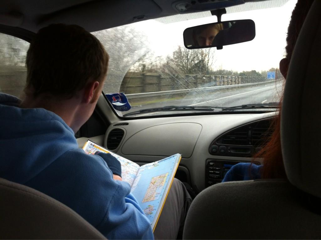
We sped down the M11 tracking the balloon in real time, passing the sporadically gained balloon’s elevation, azimuth and distance-from-launch-site data on to Science Officer Chylik at Mission Control. Here this data was converted to latitude and longitude data and constantly updating predictions were made about the balloon’s flight path and landing area. As all we had to go on was the pressure and temperature data to guesstimate heights we just headed SW and carried on relaying the data as it came in.

1200hours: 1hour 00minutes flight time

After a rather relaxed morning and a pub lunch somewhere near Harlow, the Chase Team (driven by Captain Gooch, led by Tactical Officer Surl and completed by Ensigns Huezé, Davies and van der Weil) set off fearlessly in hot pursuit of the balloon which had been predicted to come down between Welwyn Garden City and Cheshunt.

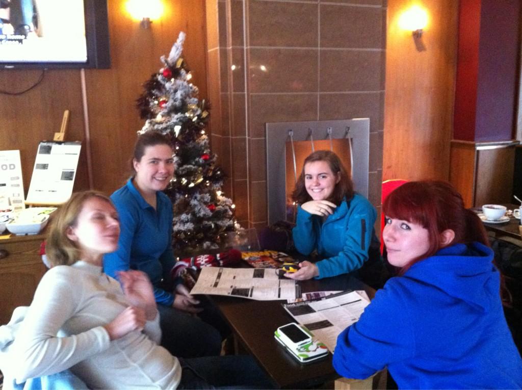
The Chase Team having a very taxing morning (photo by L. Surl)


1243hours: 1hour 43minutes flight time

As I sat in the back of the speeding (not literally) Mobile Command Centre, intensely staring at the computer tracking readouts, the pressure and temperature data which had both gradually been falling and had reached around 13hPa and -67oC respectively suddenly started increasing; burst had occurred at approximately 28,210m over Northhampton. The slow rate of increase suggested that the parachute had deployed successfully and this was confirmed when the radiosonde started to report actual altitude data showing a perfect descent rate of 4m/s. Science Officer Chylik came into his own at this point, constantly updating predictions while we parked up at Watford Gap services to increase radio signal accuracy.


Professor von Glasow attempting to boost signal accuracy


Mobile Command Centre in action trying to pinpoint the balloon's last known loacation

1315hours: 2hours 15minutes flight time

Unfortunately we lost radio contact around 0115hours at approximately 2500m altitude and so the landing predictions were somewhere within a rather large ellipse around Oaklands Forest, Hertfordshire. The Chase Team were rapidly deployed to search this area and Mobile Command sped down the motorway to assist.

Chase Team in action

1350hours: 0hours 40minutes after losing contact; 2hours to sunset

The chase team arrived in the predicted landing area and proceeded to search on foot, splitting into 2 search parties to cover ground more quickly.

1500hours: 1hour 10minutes after losing contact; 50minutes to sunset

Mobile Command also reached the search area, searched the dense woodland below the balloon’s last known location and tried to recruit as many passing dog walkers as possible to keep an eye out for it. Even though we knew the odds were greatly against us finding anything in this terrain we continued tirelessly until it got too dark to see around 1600hours and were finally forced to concede defeat. Headed to the local pub to meet up with the Chase Team, having to rely on someone finding the box for us and the contact details on the side having survived the trip.

2000hours: 6hours 10minutes after losing contact; been awake for 37hours

Finally arrived back at ground control for commiseration drinks and pizza, while we did not recover the box on the day all is not yet lost and Hertfordshire’s local police and media have been notified in case anyone reports seeing anything strange in the sky or actually finds it. Also, this was still a very successful shakedown flight showing us that the payload delivery, high altitude tracking and landing system worked very effectively and that for future missions we need to develop a way of tracking the box’s ground position – most likely by investing in a cheap Android mobile phone with an app that can relay its co-ordinates by text message.

Full live tweet coverage of the launch and recovery attempt can be found at @UEABLEAT and will also be covered in next week’s issue of Concrete, all photographs I took on the day are here.

Friday 30 November 2012

One small step for man, one giant leap for Norfolk


So for the last few months the main item of procrastination within the department has been to form The University of East Anglia’s space program. This is a collaboration project of UEA PhD students and faculty members who have formed an organisation codenamed BLEAT, the Balloon Launch Exploration and Analysis Team, and also known as ARSE, Andrew Rushby’s Space Explorers (our website). Since Commander Rushby (see his blog to see just how much he really loves space) first proposed the idea of establishing Norfolk’s long overdue position in the race to commercialise spaceflight back in March we have been putting a lot of time into making this dream a reality. This is unlikely to aid anybody’s actual work, we’re just doing it for an excuse to do some exciting science in space, because we can and basically (to paraphrase Mallory before he attempted the first ascent of Everest) because it [space] is there.

Bleat Logo, designed by J. Shirley


The first mission, with launch scheduled for 10:00 hours GMT tomorrow (01/12/2012) is a preliminary mission to send cameras and a GPS tracking system attached to a weather balloon up 30km to the edge of space. As well as hopefully getting some cool photos this should allow us to test our methods of launch and recovery so future missions can have a more advanced payload – there’s talk of developing an ‘air-core’ unit to sample the air column at varying heights and also to maybe send some single-celled organisms up as Norfolk’s very first astronauts.

Scale schematic of the space balloon launch and recovery system

As Chief Engineer, it’s been my primarily my job to develop the launch vehicle and make it space worthy. This has mostly involved scrounging materials from the labs and building the ‘Spacebox’ the (hopefully) space-proof capsule that will contain and protect our payload from the hostile environment of near-space. At ≈33km up (the maximum our balloon can reach before exploding as it expands to 20 times its launch diameter) It will have to survive low pressures that would make your blood boil and tissues explode and temperatures down to -80oC, and then survive the ride back to Earth attached to a rather small parachute, so it’s been heavily insulated and securely duct-taped to perfection (although it has to still be able to vent excess pressure so is not completely air-tight).

'Spacebox' launch capsule (photo courtesy of H. Chylik)

The top-secret launch site – a field in Burton-on-Trent – has been carefully selected by our team of resident Meteorologists led by Tactical Officer Surl. Using computer simulations (developed at Cambridge University) to predict the balloon’s path as it is strongly influenced by the weather conditions and changes in the jet stream this is the closest location to Norwich we can launch from if we want any hope of our payload still landing in East Anglia. Just in case, attached to the capsule are multi-lingual instructions for its return in English, French and Dutch, kindly translated by members of our international team, although if it does not land before reaching the coast it is likely it will end up on the bottom of the North Sea.

Today the final preparations have been put in place, after we finally got CAA approval yesterday, first thing this morning we tested whether it would be possible to transport the balloon fully inflated – to get around regulations on transporting pressurised gasses – but unfortunately it was too big to fit it Captain Mill’s balloon transport vehicle (BLV aka camper van). Luckily however Admiral Professor von Glasgow is fully trained in pressurised cylinder transport and has kindly volunteered to separately drive the helium up for us while we follow in the BLV.

Once launched we will track the balloon’s progress using the GPS system and, orchestrated by Science Officer Chylik running ground control out of UEA and predicting the flight path, the chase team led by Captain Gooch will fearlessly race across East Anglia to recover the payload, or to hopelessly watch it crash (possibly in flames) into the sea.

None of this project would have been possible without the time and dedication by many more people than it has been possible to name above nor the money kindly donated by the UEA (with surprisingly little begging involved. A further mention needs to go to the journalist Michael Brown who has been following us for the last few weeks to put together press coverage for Concrete (UEA’s student newspaper) and has also been instrumental in securing extra funding from the Student Union.

(most of) the BLEAT Team (photo courtesy of H. Chylik)

An update on the outcome of the launch will be posted next week, although you can follow our Twitter feed for exciting live updates, but I thought I should write this pre-launch just in case it all goes wrong while we’re still relatively optimistic and nothing has yet crashed and burned. However, whatever we do, it's never going to be as cool as this by some students from Harvard:


Monday 5 November 2012

Abuse of power


So, now the students are back, for the last month or so my work’s been pretty much on hold while I've been demonstrating non-stop for the undergraduates. Somehow I've ended up helping on second year module practicals for both Tectonic Processes and Sedimentology, subjects I've not gone anywhere near since being a confused undergrad myself.

Tectonic processes was definitely the most fun of the two, with half of the practicals involving messy experiments, such as using cornflower paste (which one student did keep eating), strips of plastic and wooden canes to look at how varying the rates and amounts of applied strain affected how different materials deformed as analogues for various rock types in the Earth’s crust. The most impressive was using wet sand to produce a half graben by piling the sand on top of plastic sheets and then pulling them apart, which, if the sand had exactly the right moisture content, worked really well, producing a nice series of stepped faults perpendicular to the direction of applied stress. Although trying to keep a straight face demonstrating this with my supervisor at the front of the class while the students on the front table made horrific innuendoes about the shape of the faultzone I was sticking my fingers into kind of failed.

The best part of demonstrating for gullible, trusting undergrads is definitely being able to tell them whatever you want and they will believe you so long as you keep a straight face. The other week they were looking at faulting around the North African craton (paper here) and had to work out why the faults were going around it rather than through it by looking at this figure:

Stress envelopes of the lithosphere around the East African Rift System (Albaric et al., 2009)
As can be easily seen from the strength envelopes, the real reason the faults go around the craton is because it is much stronger down to greater depths than the surrounding (younger) crust. However, it was too easy to convince the students that the faults were going around the craton because Lake Victoria is in the middle of the craton and you obviously can’t fault through a lake as water does not deform in a brittle manner. I did have to eventually go back and help them get to the real answer as otherwise they would have ended up writing that bollocks in their exam or coursework. Although this still isn't in the same league as managing to convince the girlfriend the other week that if the proposed badger cull had gone ahead, swan populations would spiral out of control, as the badger (with its semi-aquatic lifestyle and massively strong jaws) is their only natural predator…

My favourite question from one of the students, in one of the Sedimentology practicals, was a guy asking if the ichnofossil (I think it was a cruziana; an arthropod feeding trace) he was looking at was in granite. If I hadn't already spent half the class arguing with one of the professors over whether one of the samples was actually a sedimentary rock or not (I thought it was an igneous rock (a gabbro) rather than a very immature breccia which she eventually convinced me it was) I should have attempted to convince him that strange thermophilic arthropods did actually live in magma chambers, rather than just admit it was a slightly metamorphosed sandstone/quartzite. Although the majority of these practicals were rather like pulling teeth, how hard is it to describe a mudstone?

Could evil, intelligent magma dwelling trilobites have left tracks in granite?
This Saturday I ended up on a fieldtrip to look at coastal sediments on the North Norfolk coast, as is customary for any geology trip I was hungover and the weather was horrific, cold, wet and windy. This was especially fun for the undergraduates who had decided they wouldn't need waterproofs – although one did bring an umbrella which I'm amazed survived the whole day. Luckily both myself and the other demonstrator were only there to make up the numbers for health and safety purposes, as neither of us knew anything about what was being taught. So, basically, it was like we were undergrads again, stood at the back of the group learning about how cynobacterial mats consolidate sediments, what life is like for a diatomaceous slime and the formation processes of various forms of ripples, while actually getting paid for it. It was nice to get information spoon fed again, I didn't realise just how easy being an undergrad is – it seemed a lot harder the first time round!

This week the students are off on their ‘reading’ week (nobody ever reads), so I should be back doing my own science. However, my mass spectrometer is, of course, broken again. I had to dismantle it a couple of weeks ago and I've now been waiting for the workshop to lathe me a new part for a fortnight. I do think this is a good thing as it means I've actually got very little to do other than play about with old data and prep samples for when it’s finally up and running again, giving me a much needed break from swearing at the damn machine and plenty of time to mess about with other projects as we’re currently in the middle of something rather special, but there’ll probably be more on that next time…

How does this go back together again?

Friday 28 September 2012

To boldly do geology where no man has done geology before


So it’s been a while since my last post as the university has been pretty quiet over the summer and it’s been a good time to get my head down and crack on with some serious sciencing without the disruption thousands of undergraduates bring. However, after seeing this morning that the Curiosity Rover had been doing some sedimentology on Mars,, I couldn’t help but get a little bit overexcited. Doing geology in space must be every lithophile’s (see one of my previous posts) dream job and so here’s a post of my ramblings and ill-informed opinions on Curiosity and space geology and why it’s the best thing ever (and also why I hate it).

This morning’s news report on Martian conglomerates (hereand here) is some serious proof that a significant amount of flowing water must have been present at some point on the surface of Mars. Very poorly sorted (i.e. those with a wide array of particle sizes) conglomerates with sub-angular to well-rounded clasts, as can be clearly seen in the photos, can only be formed by deposition from (relatively) fast flowing water. Wind transport, which does occur due to the high Martian winds (see here) and also creates well rounded clasts, generally creates a well sorted deposit such as an aeolian sandstone as smaller particles are winnowed away and larger pebbles don’t roll so far.  A poorly sorted deposit could have been formed by some sort of terrestrial gravity flow, a slump or a slide, however, this would produce a breccia with highly angular clasts as these terrestrial flows do not travel a great enough distance for transportation processes to erode the particles enough.

Curiosity's photo shows Martian conglomerates look just like Earth ones

The calculation that "From the size of gravels it carried, we can interpret the water was moving about 3 feet per second, with a depth somewhere between ankle and hip deep," [Curiosity science co-investigator William Dietrich of the University of California, Berkeley] put me straight back to undergraduate sedimentology lectures and the Hjulstrom Curve. 

Hjustrom Curve
This graph (see above image) is a well-used tool by sedimentologists studying fluvial transport processes in Earth systems to allow the back-calculation of the velocity of water flow that deposited the sediment by showing what size material will be entrained, transported and deposited by different velocities of flow. From both the description of this shallow, fast moving stream and looking at the deposits I’m put in mind of braided river channels in upland areas arid areas like this (but without the shrubs):

Braided river system (image from http://faculty.gg.uwyo.edu/neil/teaching/geologypics/braided.jpg)

Now for a little rant, but first I’ll put this all in context with my work. I work on high resolution geochemical analysis of fossil corals and half of what I have been trying to do for the last 12 months is high resolution trace elemental analysis. For this I stick my coral stem into a machine called a laser-ablation-inductively-coupled-mass-spectrometer (LA-ICP-MS for short), which is a room-sized, very expensive, serious piece of kit. In short, this machine uses a laser to vaporise the carbonate, this  vapour is entrained into a gas which is superheated to around 10,000K and ionised to form a plasma which then goes into a mass spectrometer where the proportions of ions of various elements that make up the sample are analysed. This is done along a tract of the coral wall, producing over 3000 readings for a sample less than 50mm long and should, in theory, let me see seasonal changes in trace element composition allowing me to investigate growth conditions (see this paper where they've managed to do it on modern samples). I say ‘in theory’ as I have yet to get any meaningful data from this technique, all I have produced are noisy squiggles of data which cannot be calibrated to any quantitative figures. So while I can see what elements are present, I have no idea of the proportions they are in, and thus cannot draw any conclusions, and I have no real idea why.

Now, with that in mind, you may see why Curiosity annoys me. This little robot travels over 120 million miles through space, successfully lands on another planet, drives around a landscape no human (and very likely nothing else) has ever set foot on, and finds a rock (named ‘Coronation’). All in all a very impressive feat of human engineering which we should all be proud of. But then it, and for obvious reasons this is what I can’t deal with, it fires a laser at the rock, ablating it and producing an ionised plasma in the exact same way I do here, and using it’s ChemCam spectrometer it analyses the elemental content (shown below) of said rock from the produced light spectra of the ions in the plasma, and discovers it to have the composition of a bog-standard lump of basalt (details here). Ok, so the rover may be analysing at a lower resolution and using light rather than mass spectrography, but still, how can it get real, meaningful results in space, at a distance, outside the laboratory, in a non-vacuum, uncontrolled environment, using a machine maybe a hundredth of the size of mine, when I can’t???


Unfortunately, the answer is funding and expertise, things NASA has a hell of a lot more than I do for my research (even with the generosity of NERC and UEA). So, as I can’t do anything about this I’ll end this rant with a plea; please NASA, let me be a space geologist too (as if you can’t beat them, join them).

Sunday 24 June 2012

Confessions of a Lithophile


So, very little interesting has happened in my life/work since my last post so I thought I would use my monthly update to comment on the perils of being a geologist in public, or more accurately why we should not be allowed around normal people and rocks at the same time.

At the end of May I went hiking in the Lake District with UEA’s Fell and Mountaineering Society. (Un)fortunately for them the areas of the Lakes we visited had such an interesting geology once a couple of people had asked a few questions, stupidly letting me know they were vaguely interested, I couldn't help myself in commenting in whatever we were walking over at the time.

Being in the central lakes we were mostly scrambling around on rocks of the Ordovician (around 450Ma) Borrowdale Volcanic Group; lavas, ignimbrites and volcano-clastic sediments. These formed at a time when subduction was closing the Iapetus Ocean and forcing continents together. This triggered massive eruptions which created a large and very active volcanic island arc as oceanic crust was forced under the ancient microcontinent of Avalonia (whose rocks underlie much of England and Wales, Snowdonia formed around the same time under similar conditions) which was then residing in the subtropical southern hemisphere. About as far removed an environment as possible to the peaceful misty mountains that now serve as our only reminders of this violent time.

On the Saturday we climbed Hellvellyn which appeared to be mostly made up of Lavas, many of which had a very nice amygdaloidal texture – where the vesicles (holes where gas bubbles solidified) have filled in which another mineral, often zeolite, to create a distinctive white spotty texture contrasting the dark lava rock. The term amygdaloidal (from the latin for almond; amygdale) actually refers to the stretched shape of the infilled vesicle, created by the stretching of the original bubble by the flowing viscous lava. I may have explained all this several times throughout the climb to anyone dumb enough to come up to me with a, “what’s this, it’s pretty” or similar...and then probably almost instantly regretting it as I went through an in depth explanation of the formation of these features.

Look, I've found a rock!
The next day was even worse, I forget the name of the mountain we went up – some well known scramble route near Scafell – but it was completely made up of a beautifully preserved ignimbrite, the lithified remains of pyroclastic flows (deadly currents of superheated gas and ash which can travel up to 450mph, here's a good compilation video of explosive eruptions with pyroclastic flows and Plinian plumes: pyroclastic flow movie) from explosive volcanic eruptions, which must have been pretty long lived and catastrophic to produced the hundreds of meters worth we scrambled through. Having seen recent (well around 200Ka as opposed to 450Ma) ignimbrite deposits in Tenerife on a field course in my Master’s year I knew what I was looking at and  I was amazed to see how all the features were still visible after all this time, and the rocks were still sharp – my hands and knees got shredded.  All the classic components were present, from erosional bases with low angle bedforms, showing discrete eruptional events had violent pyroclastic flows which ripped up previously deposited layers, to pumice layers and fine ash with accretionary lapili (concentrically ringed balls of ash formed as particles roll around in turbulent plumes in phoenix clouds above the pyroclastic flow) showing fallout from the Plinian plume. How am I not supposed to get overexcited and point things like this out to people?


Ordovician ignimbrite deposits, Lake District
Now this obviously isn't the first time this kind of thing has happened, a few weekends ago (when we had the one week of summer) I went to a beach with a friend. As the sea at Cromer (North Norfolk) didn’t look particularly inviting we just laid on the beach and ended up playing I Spy (I may have mentioned how cool I am). Surprisingly she wasn't impressed; it turns out syn-sedimentary faulting and onlap (in the Quaternary esturine and fluvial deposits exposed in the cliffs (Norfolk geology)) and even flint are not acceptable things to ‘spy’ if you’re not playing with a fellow geologist. Another time I was walking with a group of friends (again around the Norfolk coast) who couldn't understand my interest in the fact that the local council were using huge blocks of some sort of pyroxene (couldn't get close enough to check which) cumulate as coastal defences, as far as I know there are no large mafic intrusions around East Anglia so this must have been brought in from miles away. And on a night out last week myself and a fellow geologist were explaining to the barman the formation processes behind the zoned plagioclase phenocrysts (big white crystals) in the 'granite' bar top, even though it was just a stuck on laminate. Even my holiday photos are dominated by interesting rock formations.
Some nice bedded sandstones, near Macclesfield
Now what I am wondering is, is it time to get lithophilia recognised as a real, mental condition so that we can get help (I know for a fact I am not the only sufferer) or should ‘normal’ people just learn to accept us for who we are, love rocks and embrace the weirdo who thinks it’s normal to carry a hand lens around at all times?

Thursday 17 May 2012

Italy March 2012 - Sun, sand, sea and corals?


Last week was my latest field trip, this time to Southern Italy (with one of my supervisors) to look for samples of Pleistocene-Holocene marine fossils, mostly interested in the coral Cladocora caespitosa, in the uplifted marine terraces exposed around the coastline.

The marine terraces in the south of Italy are uplifted thanks to the tectonics of the Mediterranean region with various uplift rates in different areas thanks to the complex interplay between regional and local tectonic regimes in this highly active region. The country is squashed by the growth of the Apennines thrust belt to the east and stretched by the Tyrrhenian back-arc basin to the west due to the westward subduction and eastwards roll-back and delamination of the Adriatic-Ionian plate. The delaminating lithosphere under the south of Italy further increases the rate of uplift as dense material is removed from its base, causing the slab to ‘float’ higher on the mantle (see Ferranti et al, 2006 for a nice overview). Because of this expansive marine (and fluvial) terraces spanning numerous ages are accessible along the coast, increasing in age with height gained, going completely against the normal rules of stratigraphy.

Where we went

 We wanted to get samples from both of the Italian coasts to compare to what we got from Greece as the Gulf of Corinth is pretty much a closed system and we want to compare the climate signals from this to the open ocean of the Mediterranean, adding a spatial as well as the temporal element to the study.

After months of planning and trawling the available literature to find localities where uplifted sediments and C. caespitosa had been found previously I thought it would be easy to find these sites and get plenty of samples. However it turned out that this really wasn’t the case; we spent hours driving around just finding massive amounts of fluvial conglomerates or getting to a supposed locality and finding that someone had put a housing development there since the paper reference was written. When we did find a locality it really was a case of grabbing as many samples as possible to make up for the difficulty, often risking life & limb – such as dangling off an unconsolidated cliff face, directly above a train track – to get the best ones.

Le Castille on the Capo Rizzuto peninsula, actually has corals in the stones they used to build it, didn't think it was a good idea to sample them

Although probably too old for the samples to be much use, the most amazing locality I’ve seen yet was the ‘Coral cave’ above the village of Tarsia. Although undated, judging by the elevation (~225m) and the level of preservation of the fossils it looks like this outcrop may date back to MIS 11 (~400kyr old). This location was studied by Bernasconi et al, 1997, and directions to the site were kindly provided by her, she even visited the site to check it was still accessible for us. As you can see in the photographs the cave is cut right into a C. caespitosa reef so the walls and roof of the cave are almost completely made up of massive, branching corals (conditions were obviously perfect for growth at this time).  What made the site even more impressive were the thousands of burrowing sand bees that are living in the sandy layer that the reef had established itself on, these were a little worrying at first but they seemed harmless and completely untroubled by our presence.

Tarsia 'Coral cave'

Massive C. caespitosa colony found in cave

While we had issues with the science, the trip made up for that with amazing food and weather. The worryingly forecast regular heavy storms failed to materialise (the one time it rained we were in the middle of a long drive) and we saw 30oC pretty much every day. This was very lucky as I’d failed to check that the tent I had borrowed for the trip actually had tent pegs and guy lines in it. Had to improvise with whatever I found lying around the campsite with sharpened twigs, rocks and a bent cutlery set all being used on different nights. I don’t think any of these would have stood up to much bad weather though. The amazing weather did have its downsides however, trying to work on beaches looking in full field kit while surrounded by bikini clad Italians is surprisingly off-putting.

Tent held up with cutlery AND rocks!

 On the food, we mostly ate in the Italian equivalents of service station/truck stop restaurants. However, while in this country you have to deal with a terrible fast food burger or overpriced Ginsters, there (for around the same price) it was amazing shellfish risottos, pasta and some of the best pizza I’ve ever eaten  (and I’ve eaten a lot of pizza), all with very good locally produced wines. Truck drivers are very well catered for in the south of Italy, as well as this amazing food, even in the middle of the day all the laybys along the main roads are full of prostitutes, which does make working on roadside exposures pretty unpleasant.

One worrying moment of the trip was, after spending hours of searching, finding out that the one open campsite around the area of Isola di Capo Rizzuto was naturist only. Luckily, it not being the tourist season they were desperate for custom and allowed us to stay with our clothes on for a night and the other few occupants were also thankfully dressed (nudists are NEVER the kind of people you want to see without their clothes). Unfortunately, this campsite, like most of the other sites we visited, was inhabited by incredibly noisy nocturnal birds, they make a sound like a sonar which is impossible to sleep through.

All in all it was a good (if intense) week, I’m still knackered now almost a week later but that may have most to do with the shear amount of catching up and post-trip sorting out I’m in the middle of than the fieldwork itself. Now, where to go next...

Monday 23 April 2012

Rock Bothering, Cider & Jenga (Slapton Field Course 13-20/04/2012)


So last week was spent demonstrating on a first year Environmental Sciences undergrad course to Slapton in Devon.

The week started off less than promisingly (well we'd started a field trip on a Friday the 13th so what did we expect) when we thought we’d lost a student at Reading services, after the initial panic when no one seemed to know who he was or have his number turned out he’d just swapped coaches without anyone noticing…obviously a popular guy.

My job for the week was to demonstrate on the geology-based activities which mostly meant I had to get students to be enthusiastic about rocks, even getting some students to actually look at them was challenging.
The first two mornings activities were spent topographically surveying the Slapton Ley beach barrier. The Ley itself is a freshwater lake with SSI status due to providing a unique habitat for many species of plants and animals, this body of water formed when sea levels rose at the end of the last ice age and created the shingle ridge. The students were looking at changes in sediment lithology and particle size up the beach profile and using resistivity and conductivity methods for the depths and composition of the water table. These surveys were to attempt to look at the future sustainability of the Ley as sea levels rise over the next century. By comparing the main sediment type (flint) to the known geology of the local area it was found that the main sediment source was an offshore flint bank.  This source is not being currently renewed and so as sea level rises, and the sediment source decreases, the barrier will not be replenished and so will retreat or be overtopped by the sea, destroying the Ley and the main transport route through the area. The geophysical results were a little more ambiguous, mostly due to the repeated failure of numerous pieces of equipment, but seemed to show that salt water was not permeating far through the barrier and so was not polluting the Ley, although this could too change as sea level rises. The highlight of these activities were the sampling methods the students came up with to ensure they collected a random sample of pebbles; these included one student sitting on the ground and reaching behind himself to pick up pebbles so he couldn’t bias the sample by seeing it and another group with 2 students standing on the spot with their eyes closed; one waving a stick around and the other telling him to stop so they’d collect whichever pebble the stick pointed at. I found out later one of the students had also managed to lose both his shoes to the sea while surveying too close and not looking out for waves.

Slapton Sands beach barrier and ley


One afternoon was spent doing lichen chronology (see Winchester & Chaujar, 2007 for an example) on gravestones around the local church. All the students had to do was pick a consistent gravestone lithology and a type of lichen that grew on those stones and compare lichen diameter to age of the gravestone to make a calibration curve. Unfortunately we had students that couldn’t tell the difference between granite and marble and in one case slate and wood (“This gravestone feels like it’s made out of wood”)! Most calibration curves turned out to be just a random scatter of points although I doubt this was the fault of the students as the method has so many variables and assumptions (e.g. gravestones may have been cleaned for a while delaying colonisation, different conditions of light and shelter in different parts of the graveyard, etc.) I don’t think it would have worked properly anyway. I think I prefer my contact with lichens to be limited to just scraping them off rocks to find a fresh surface to look at, although this seems to annoy the ecologists somewhat.

A major challenge was attempting to teach students with massive hangovers various geological techniques (logging, using compass-clino’s) on the beach while a dog was running around with a lump of quartz in its mouth, trying to give it to students and digging holes in the sand which was admittedly more interesting than what they were supposed to be doing.

One the same day as the dog we had a very impressive bus driver who managed to almost get the bus stuck in a very narrow village and had to reverse a mile backwards down a country lane, only demolishing one wall in the process while being heckled loudly by a local with a pony.

The last two teaching days were full days of geology. The first sedimentary; in the morning looking at a good outcrop of Permian desert sands with clear wadi (flash flood) deposits at Fairy Cove, Torbay. Here we had a succession with breccias, cross-bedding and dessication cracks and mud lenses from dried out puddles and streams, a lot of stuff for the students to look at to deduce processes and environment of deposition as the fast approaching  tide tried to cut us off. The afternoon was spent looking at Devonian reef limestones;  these were absolutely rammed full of fossils of corals, stromataporids, bryozoa and brachiopods up until a period of intense volcanic activity (shown by a thick ash bed) killed off the reef and the remainder of the succession is pretty sterile, summarised expertly by one student, “Basically the volcano just raped the ocean”. The second of these two days was spent up on Dartmoor looking at the granite and its effects on the surrounding country rocks with contact metamorphism (slates going into spotted slates with cordierite) and hydrothermal mineral precipitates (mostly unidentifiable brown stuff, presumably some form of iron oxide).  Was not expecting Environmental Sciences students to moan so much about having to walk up hills although I’ll let them off moaning about being caught in an ice storm (it was too bad to be just hail) where we couldn’t even see the other side of the valley, I ended up just laughing hysterically at them all huddling together as they had to face the hail to see the lecturer, which caused no end of dirty looks.

The last two days the students had to do independent group projects to create poster presentations, which basically meant we got a couple of days off, just checking up on them from time to time. In my case this meant walking up & down the beach for a morning and hiding in a bird hide when the weather got too bad laughing at the thought of the students still working out in the torrential rain. In spite of the weather some good projects & posters did come out of this, unfortunately I wasn’t allowed to give extra marks to a group that had taped rocks to and got lots of bad geology puns in their poster.

What was most annoying about the week was the lack of preparedness of many of the students, why anyone would think trainers, ugg boots, tight jeans, no waterproofs or (in one case up on Dartmoor) an umbrella would be a good idea for fieldwork? Although at the other end of the spectrum the girl who wore chest waders to the beach on a nice day was a bit extreme!

Spent every night in the local pub (The Queens Arms) drinking too much of the local cider (Devon Mist, very nice) and playing very intense drunken games of Jenga. Although on the last night of teaching we got a bit carried away on the tequila & vodka and didn’t all make it on time for breakfast and the morning’s activities.

Impossible Jenga


On the last night we had a good bonfire on the beach, was surprisingly tame although 2 students had to be repeatedly pulled away from the fire as they kept drunkenly falling/rolling way to close to it (one girl repeatedly shouting, ‘It’s OK, I used to be a Scout, we’re pyromaniacs”) and 3 guys had to be pulled out of the sea (one fully clothed), although this only added to the night.  There were some rough people on the coach the next morning, although for once I wasn’t one of them, must be growing up, or not.